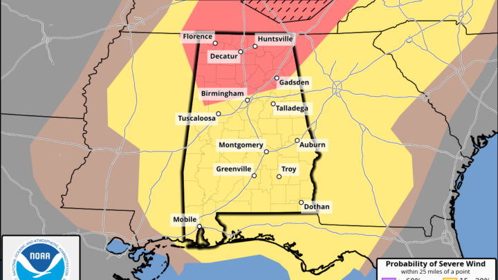
Aiming To Prepare, Not To Scare
Coverage Zone 3 is Jackson, DeKalb, Cherokee, Etowah, Calhoun and Cleburne
SUMMARY: Fire Weather Warning and Freeze Warnings are currently in effect for different parts of Alabama. The Fire Weather Warning is in effect from 10 am to 7 pm CDT for north and central Alabama. Freeze Warnings are in effect from 11 pm Tuesday until 9 am Wednesday for north Alabama, and a Freeze Warning…
Cullman NOAA Weather Radio transmitter is offline for those listening in north-central Alabama. You will need to tune to a new station to receive warnings and the latest weather information: NOAA Weather Radio All Hazards transmitter WWF-66 operating on a frequency of 162.450 MHz will be off the air until further notice. You can tune…
Temperatures will rise into the 100’s Thursday afternoon. The combination of these temperatures with humidity values will make the feel like temperatures, or heat indicies, reach the mid 100 mark. Excessive Heat Warnings and Heat Advisories are in place for a large portion of our Coverage Zones as a result. These are upgrades from the…
As the week moves along, so will the temperatures. Heat indices are expected to reach the mid-upper 100s on Thursday. As such, an Excessive Heat Watch is in effect for areas along and west of Interstate 65.
A Slight Risk (Level 2/5) has been put in place by the Storm Prediction Center for much of Alabama on Sunday, June 25th. Multiple rounds of strong-severe storms are expected in the late morning on Sunday then again Sunday night into the overnight hours. Damaging winds and large hail will be the main threats. …OH…
SUMMARY: Windy conditions will develop today ahead of an approaching line of strong to severe thunderstorms. The line is expected to reach the MS/AL state line between 10-11 pm tonight and exit into Georgia between 3 and 7 AM Saturday morning
SUMMARY: We have been highlighted in a Level 3/5 Risk for severe thunderstorms Friday night into Saturday morning. The hazards include damaging winds, tornadoes, large hail, and flash flooding. AREAS AFFECTED: All of our Coverage Zones of north and central Alabama. TIMING: 10:00 PM Friday until 3:00 AM Saturday POTENTIAL HAZARDS | RISK | CONFIDENCE…
SUMMARY: A line of strong to severe thunderstorms with the potential for damaging wind gusts, hail, and a tornado or two will be possible Thursday morning TIMING: Thursday morning – 1/12/23 AREAS AFFECTED: All of our Coverage Zones of north and central Alabama POTENTIAL HAZARDS: Damaging winds of 60 MPH, hail up to quarter size,…
SUMMARY: Multiple rounds of thunderstorms are possible Tuesday into early Wednesday. POTENTIAL HAZARDS: 20-30 MPH winds outside of thunderstorms, damaging thunderstorm winds of 60-70 MPH inside of thunderstorms, hail, heavy rainfall, and a few tornadoes. The tornado threat is higher across the southern portion of Coverage Zone 2. POTENTIAL IMPACTS: Winds of 20-30 MPH can…