It’s been a talk for a long time, and it’s less than 30 hours away. Signs are pointing to this being the coldest arctic blast of the season. A prolonged period of sub-freezing, dangerous temperatures, and wind chills will be associated with this system, as well as some wintry precipitation in the form of snow, sleet and freezing rain, which could result in some ice and lead to some travel concerns.
Details of this event are still unfolding, and this is likely to change over the next 12-24 hours. Please stay tuned to reliable weather sources for the latest forecast.
1st up: Winter Storm Watch
Winter Storm Watches are issued ahead of time to warn of potential wintry precipitation that could lead to hazardous travel and power outages.
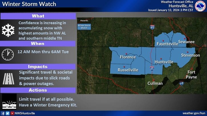
URGENT - WINTER WEATHER MESSAGE
National Weather Service Huntsville AL
403 PM CST Sat Jan 13 2024

ALZ001>007-009-TNZ076-096-097-141100-
/O.CON.KHUN.WS.A.0001.240115T0600Z-240116T1200Z/
Lauderdale-Colbert-Franklin AL-Lawrence-Limestone-Madison-Morgan-
Jackson-Moore-Lincoln-Franklin TN-
Including the cities of Florence, Muscle Shoals, Sheffield,
Tuscumbia, Russellville, Red Bay, Moulton, Town Creek, Athens,
Huntsville, Decatur, Scottsboro, Lynchburg, Fayetteville,
Winchester, Sewanee, Decherd, Estill Springs, and Cowan
403 PM CST Sat Jan 13 2024

...WINTER STORM WATCH REMAINS IN EFFECT FROM LATE SUNDAY NIGHT THROUGH LATE MONDAY NIGHT...

* WHAT...Heavy mixed precipitation possible. Total snow accumulations of 1 to 3 inches and ice accumulations of a light glaze possible.

* WHERE...Portions of north central, northeast and northwest Alabama and southern middle Tennessee.

* WHEN...From late Sunday night through late Monday night.

* IMPACTS...Travel could be very difficult. The hazardous conditions could impact the morning or evening commute. The cold wind chills as low as zero could result in hypothermia if precautions are not taken.

PRECAUTIONARY/PREPAREDNESS ACTIONS...

Monitor the latest forecasts for updates on this situation.
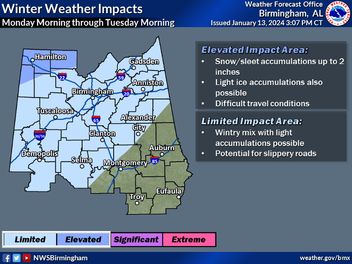
URGENT - WINTER WEATHER MESSAGE
National Weather Service Birmingham AL
209 PM CST Sat Jan 13 2024

ALZ011-014-141200-
/O.CON.KBMX.WS.A.0001.240115T1200Z-240116T1200Z/
Marion-Winston-
Including the cities of Hamilton and Double Springs
209 PM CST Sat Jan 13 2024

...WINTER STORM WATCH REMAINS IN EFFECT FROM MONDAY MORNING THROUGH LATE MONDAY NIGHT...

* WHAT...A wintry mix of precipitation is possible. Total snow accumulations of up to two inches and ice accumulations of a light glaze possible.

* WHERE...Marion and Winston Counties.

* WHEN...From Monday morning through late Monday night.

* IMPACTS...Travel could be very difficult. The hazardous conditions could impact the morning or evening commute.

PRECAUTIONARY/PREPAREDNESS ACTIONS...

Monitor the latest forecasts for updates on this situation.
Next: Dangerous cold persists until Thursday