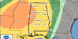
Multiple Days Of Severe Weather Possible 5/7 & 5/8

By alstormtracker

Key Points: Tuesday (5/7) ..LOWER MISSISSIPPI VALLEY/DEEP SOUTH    THIS REGION WILL BE DISPLACED SOUTH OF THE STRONGER FORCING FOR  ASCENT, BUT MODERATE BUOYANCY AND VERTICAL SHEAR STILL SUGGEST THERE  IS ISOLATED SEVERE POTENTIAL WITH ANY STORMS THAT DO FORM. CURRENT  GUIDANCE SUGGESTS THE GREATEST PROBABILITY OF STORMS EXISTS ACROSS  MS AND AL WHERE THE…

Severe Weather Potential – April 2, 2024

By alstormtracker

We’re about 20 hours away from a potential severe weather episode across the state—all modes of severe weather including damaging winds, large hail, and tornadoes. The primary threat will be damaging straight-line winds of 60-70 MPH with any thunderstorms. OVERVIEW: In terms of timing, thunderstorm development will begin around 2-3 pm across north Alabama By…

High Impact Severe Weather Event To Unfold Tomorrow

By alstormtracker

SUMMARY: The state of Alabama has been highlighted in a Slight (Level 2/5) severe weather risk tomorrow, and an Enhanced Risk for NW Alabama. Scattered to numerous thunderstorms will come in the form of a line early Thursday morning and last throughout the early afternoon hours. Hazards with thunderstorms Potential impacts Winds of this magnitude…

Wind Advisory; Strong System To Bring Strong-Severe Storms Monday/Tuesday

By alstormtracker

A strong storm system will bring increasing winds on Tuesday, with non-thunderstorm winds reaching 30-40 MPH as the system moves from south to north. The severe weather threat is limited to the Gulf Coast, with the potential for stronger storms across south-central Alabama. Moving further north reduces the likelihood of thunderstorms. As the rainfall event…