
SUMMARY: A potent storm system will bring multiple rounds of severe thunderstorms to the region as early as Thursday evening, on Friday, and the best chance being on Saturday. Please read below for the details, and prepare now for severe thunderstorms that could produce tornadoes, large hail, damaging winds, and a flooding threat.
Author’s note: The wording used in the summary is not to scare anyone, it is to catch your attention and help you prepare. Many in the world have weather anxiety, and I myself do as well. I find if you hope for the best and prepare for the worst, everything will be fine. Know what to do, where to go, and when you need to take action. We have been very active on our social media channels leading up to this event, so be sure to stay tuned as we bring you more information. Thank you for using us as a weather source, but we should NOT be your ONLY weather source. The informatio provided below is directly from the National Weather Service and the Storm Prediction Center, the ones responsible for issuing Watches and Warnings.
Round 1: Thursday
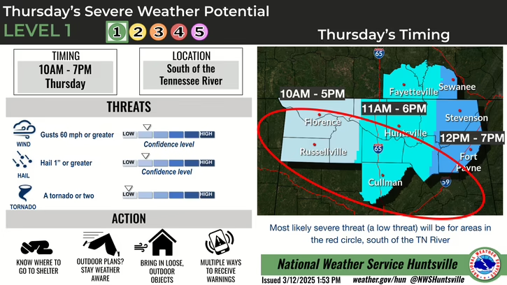
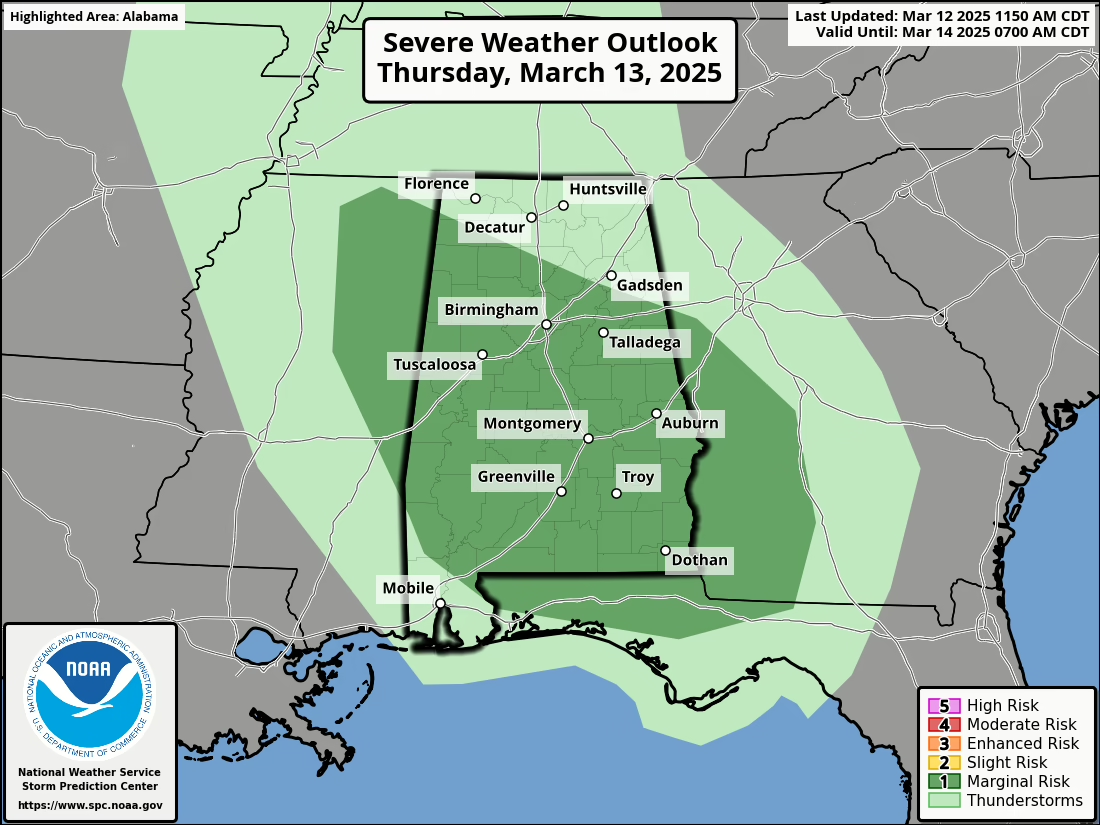
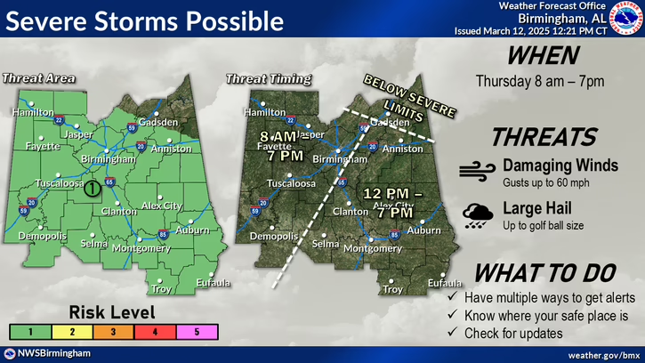
- Risk Level: Marginal (1/5)
- Areas: South of TN River into central Alabama
- Hazards: Primarily large hail, secondary damaging winds
..EASTERN MS...AL...WESTERN GA...FL PANHANDLE

AREAS OF EARLY DAY THUNDERSTORMS APPEAR LIKELY OVER NORTHERN MS,
BENEATH THE UPPER LOW. HAIL WILL BE POSSIBLE GIVEN SUCH COLD
TEMPERATURES ALOFT. FARTHER SOUTH, UNCERTAINTY IS HIGH FOR ANY
LEFTOVER CONVECTION OR OUTFLOWS COMING IN FROM THE WEST. IF A MORE
ROBUST CONVECTIVE SYSTEM CAN PERSIST OVERNIGHT ACROSS AR, THEN
ISOLATED DAMAGING GUSTS COULD OCCUR.

LATER IN THE DAY, HEATING WILL STEEPEN LOW-LEVEL LAPSE RATES INTO
AL, GA AND FL. HOWEVER, THE TROUGH WILL CONTINUE MOVING RATHER
QUICKLY, WHICH MAY TEND TO SHUNT THE MORE FAVORABLE ASCENT EASTWARD
WITH TIME. A SMALL AREA OF FAVORABLE LIFT AND DESTABILIZATION MAY
DEVELOP OVER SOUTHEAST AL, SOUTHWEST GA, AND THE FL PANHANDLE, WITH
LARGE HAIL POSSIBLE GIVEN LONG HODOGRAPHS AND COOL AIR ALOFT.
Round 2: Friday
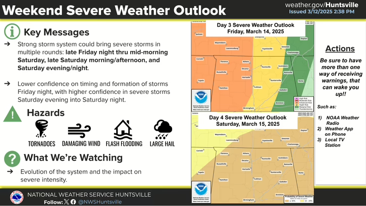
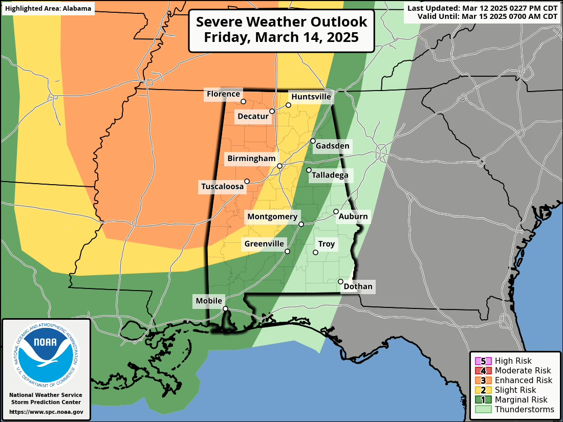

- Risk Level: Enhanced (3/5)
- Areas: Higher risk west of I-65
- Hazards: Primarily Damaging winds, secondary large hail, low threat tornado
- This will be a conditional threat that will set up the atmosphere for Saturday.
..MS/AL/TN OVERNIGHT

AS THE UPPER WAVE DEPARTS TO THE NORTH, MID TO PERHAPS UPPER 60S F
DEWPOINTS WILL SURGE NORTH ACROSS MS, WESTERN AL AND THE WESTERN FL
PANHANDLE DURING THE EVENING AND OVERNIGHT. AS MENTIONED, HEIGHT
FALLS WILL BE MAINTAINED DUE TO THE SECONDARY WAVE MOVING INTO TX.
THE RESULT WILL BE A PERSISTENT 50-60 KT LOW-LEVEL JET BENEATH 60 KT
MIDLEVEL SOUTHWESTERLIES, AND INCREASING BOUNDARY-LAYER MOISTURE.
THIS REGIME IS LIKELY TO SUPPORT SCATTERED THUNDERSTORMS AFTER 06Z,
AND THE OVERALL ENVIRONMENT CONDITIONALLY SUPPORTS STRONG TORNADOES.
THE SEVERE RISK WILL ONLY INCREASE INTO SATURDAY/D4. AS SUCH, HAVE
EXTENDED THE ENHANCED RISK FARTHER SOUTH ACROSS MS AND WESTERN AL.
Round 3, final round: Saturday


...SEVERE WEATHER OUTBREAK POSSIBLE ON D4/SAT...

   ...DISCUSSION...
   ...Day 4/Sat - Central Gulf Coast States to the Ohio Valley...

   A strong large-scale upper trough is forecast to quickly move across
   the Plains to the MS Valley on Saturday. An intense jet streak will
   move across the Deep South into the OH Valley as this occurs. At the
   surface, a low secondary to the 980 mb low over the Upper Midwest is
   forecast to develop during the late morning/early afternoon across
   the mid-South. This will aid in further northward transport of rich
   Gulf moisture into portions of the Lower MS Valley and TN Valleys.
   Atop this moisture-primed boundary layer, cold 500 mb temperatures
   are forecast. This may support fairly steep lapse rates, which would
   foster moderate instability across portions of MS/AL amid supercell
   wind profiles. However, some uncertainty remains tied to the
   evolution of convection in the Day 3/Fri period into the morning
   hours of Saturday. Some forecast guidance suggests a relatively
   pristine warm sector will be maintained, or if only isolated
   convection develops overnight/early Saturday, recovery could occur.
   If this scenario unfolds, a concerning severe weather setup
   supporting all-hazard severe could unfold across portions of
   LA/MS/AL through the day and into evening, and eventually spreading
   east into GA overnight. Trends will be monitored closely over the
   coming days and further adjustments to the 30 percent/Enhanced risk
   area may be needed in future outlooks.

   With northward extent, instability will become more limited.
   Nevertheless, sufficient moisture amid intense deep-layer flow will
   support swaths of strong/damaging winds into the Ohio Valley and
   portions of the central Appalachians Saturday and Saturday night.
   Higher outlook probabilities may be needed in subsequent outlooks if
   confidence increases.
It is during this time the potential is there for numerous severe thunderstorms that may become supercellular and produce widespread damaging wind gusts, large hail and tornadoes. Given the multiple rounds of heavy rainfall, there will also be a threat for flash flooding where thunderstorms cross the same areas.