Across north Alabama, 15 tornadoes have been confirmed from the night of Thursday, 5/8, and the early morning hours of 5/9. An additional 4 tornadoes were in Lincoln & Franklin counties in TN out of our Coverage Zones, bringing the total to 19. The events below are listed in chronological order. Credit for all the data is from the National Weather Service in Huntsville, AL, and multiple other agencies, including local EMA offices.
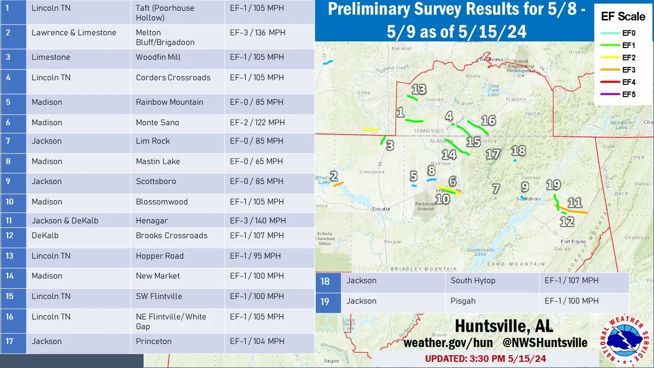
The X icons below indicate that these are not in our Coverage Zone.
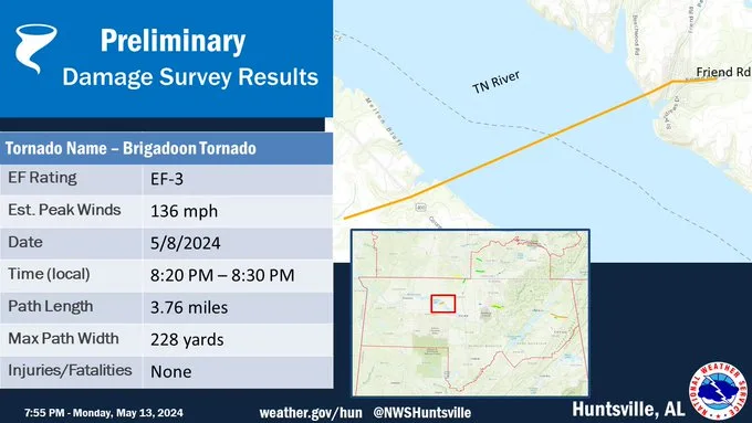
Rating:                 EF3
Estimated Peak Wind:    136 mph
Path Length /statute/:  3.76 miles
Path Width /maximum/:   228 yards
Fatalities:             0
Injuries:               0

Start Date:             05/08/2024
Start Time:             08:23 PM CDT
Start Location:         6 NE North Courtland / Lawrence County / AL
Start Lat/Lon:          34.7367 / -87.2176

End Date:               05/08/2024
End Time:               08:30 PM CDT
End Location:           8 N Hillsboro / Limestone County / AL
End Lat/Lon:            34.7556 / -87.1561

Survey Summary:
A tornado in a very remote portion of far northern Lawrence County
near Melton Bluff. It moved across an agricultural field, causing
minor damage to a large corn field. The tornado quickly
intensified to high-end EF-1 intensity, snapping off or uprooting
a large forested area. The survey team noted several of these
trees were medium to large size oak trees and significant damage
was noted in this forested area. The tornado then descended Melton
Bluff and crossed the Tennessee River into Limestone County,
moving ashore at the Brigadoon neighborhood. Public photos and
videos confirm the tornado was over water before it moved on land.
It caused damage at Inverness Place and this is where significant
damage occurred to several home. The home that had the greatest
damage had all exterior walls facing the river collapsed, the roof
of the main part of the house completely gone and the two story
four car garage was collapsed with the roof also gone. The front
of the house and interior rooms remained in tact. This damage is
correlated with low end EF-3 damage. Homes nearby had substantial
roof damage, damaged vehicles, and other various exterior damage.
Numerous large trees throughout the neighborhood were uprooted or
snapped. Moving further into the subdivision, there was roof and
exterior home damage to a lesser extent, fences knocked over by
other debris and broken windows. The tornado lifted in a field
outside of the subdivision.
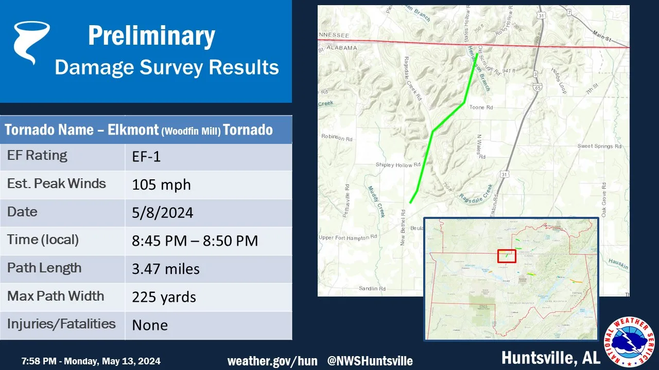
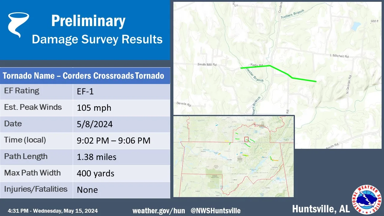
Rating:                 EF-1
Estimated Peak Wind:    105 mph
Path Length /statute/:  3.47 miles
Path Width /maximum/:   225 yards
Fatalities:             0
Injuries:               0

Start Date:             05/08/2024
Start Time:             08:45 PM CDT
Start Location:         3 ENE Elkmont / Limestone County / AL
Start Lat/Lon:          34.9458 / -86.9254

End Date:               05/08/2024
End Time:               08:50 PM CDT
End Location:           2 WSW Ardmore / Limestone County / TN
End Lat/Lon:            34.9903 / -86.901

Survey Summary:
An NWS storm survey determined a tornado touched down west of New
Bethel Rd. The tornado uprooted and snapped several large softwood
trees and collapsed more than half of a private aircraft hangar.
The tornado continued north-northeast, uprooting more large trees
and snapping large branches near homes along Shipley Hollow Rd,
which is where the tornado reached its maximum intensity of 105 mph.
Minor roof damage displacing shingles on one single-family house
was observed. Sparse tree damage was observed where it was
concluded that the EF-1 tornado's path ended just west of Old
Scrouge Rd. Special thank you to Limestone County EMA for their
assistance with this survey.
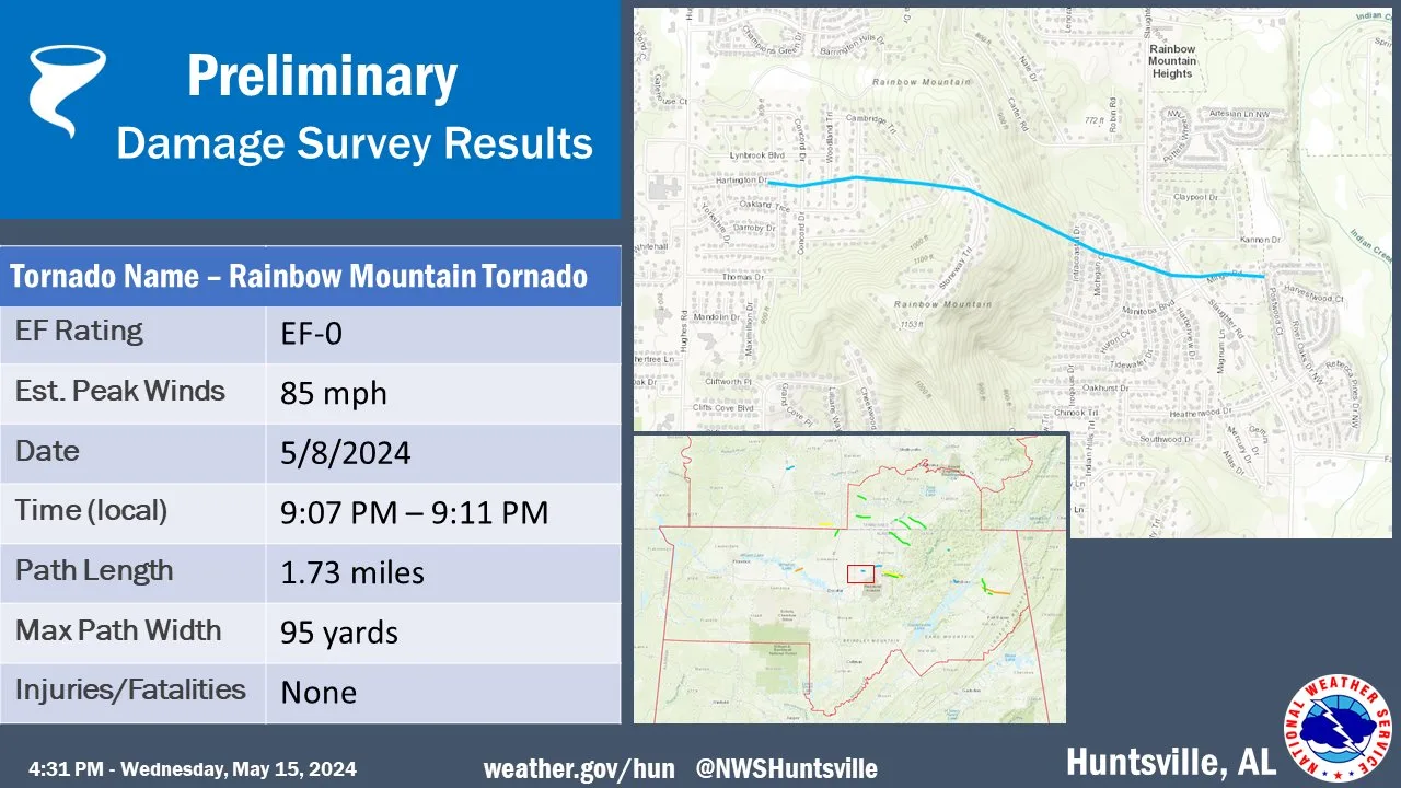
Rating:                 EF-0
Estimated Peak Wind:    85 mph
Path Length /statute/:  1.73 miles
Path Width /maximum/:   95 yards
Fatalities:             0
Injuries:               0

Start Date:             05/08/2024
Start Time:             09:07 PM CDT
Start Location:         3 NNW Madison / Madison County / AL
Start Lat/Lon:          34.7411 / -86.7364

End Date:               05/08/2024
End Time:               09:11 PM CDT
End Location:           2 NW Madison / Madison County / AL
End Lat/Lon:            34.7366 / -86.7076

A National Weather Service Huntsville, AL survey team determined
the damage in neighborhoods in the vicinity of Rainbow Mountain in
Madison, AL was associated with a high-end EF-0 tornado with max
winds of 85 mph. The damage indicators used for this assessment
were a combination of hardwood and softwood trees. The tornado
appears to have touched down in the Hillchase Neighborhood on the
west-facing slope of of Rainbow Mountain. Several trees were
uprooted in this neighborhood and with at least two trees on
houses. The tornado continued east-southeast over Rainbow Mountain
and damaged more trees in the Highland Lakes neighborhood, on the
east-facing slope. Numerous trees were uprooted in this area with
a snapped trunk of at least one weaker, softwood tree. This
damage indicator was reduced to account for the condition of the
tree. The tornado then continued eastward across Slaughter Rd.
More trees were uprooted along the Mingo Rd area. Only minor
damage was observed in the Creekwood neighborhood, into Indian
Creek where the tornado likely lifted.
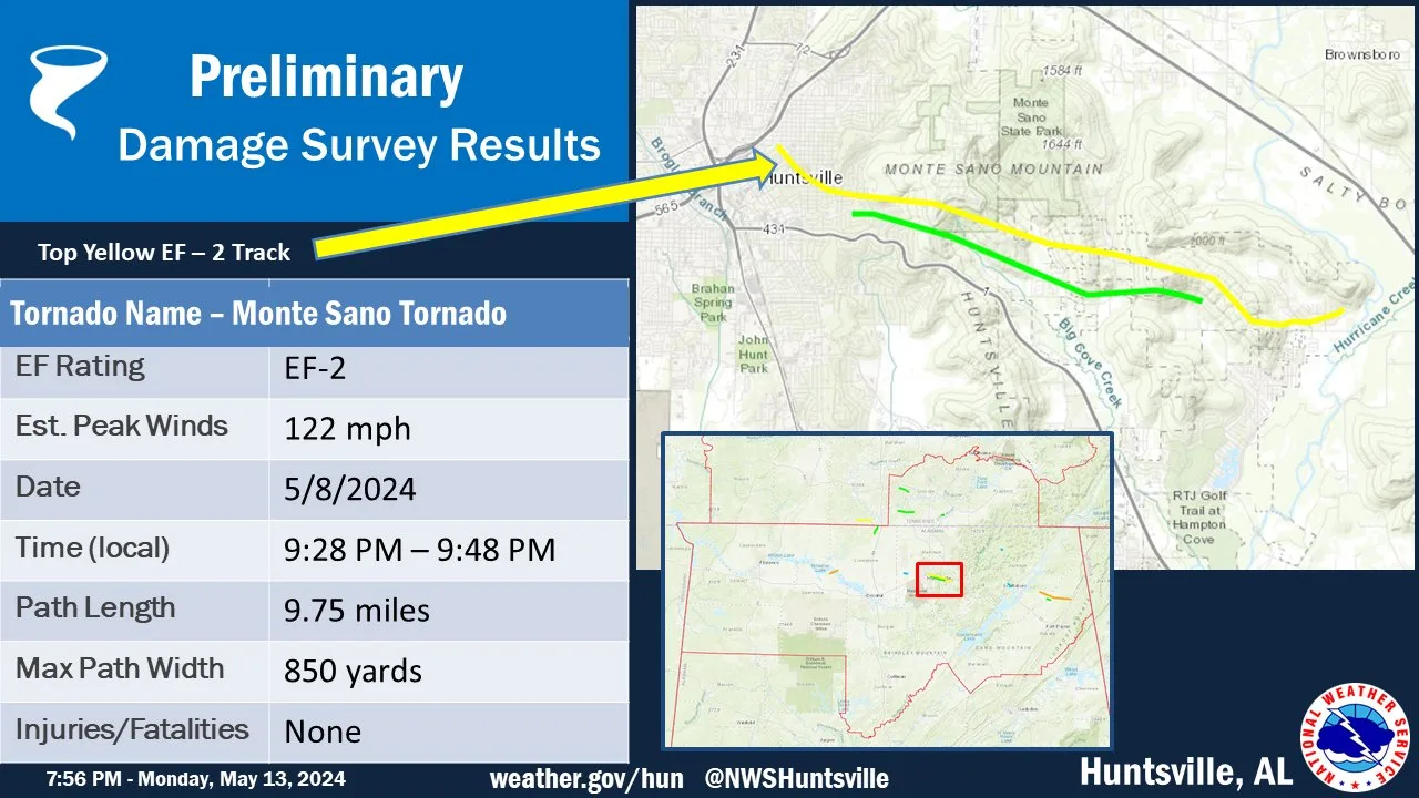
Rating:                 EF2
Estimated Peak Wind:    122 mph
Path Length /statute/:  9.75 miles
Path Width /maximum/:   850 yards
Fatalities:             0
Injuries:               0

Start Date:             05/08/2024
Start Time:             09:28 PM CDT
Start Location:         3 NE Huntsville / Madison County / AL
Start Lat/Lon:          34.7384 / -86.5804

End Date:               05/08/2024
End Time:               09:48 PM CDT
End Location:           3 W Gurley / Madison County / AL
End Lat/Lon:            34.7015 / -86.4245

Survey Summary:
A combination of NWS storm survey crews, drone imagery, and
supplemental Worldview 3 satellite imagery has determined that the
Old Town Tornado and the Dug Hill and McMullen Cove Tornado had
damage consistent with a tornado evident in previously
inaccessible areas between the tracks. The initial touchdown point
on Walker Avenue NE was indicated by snapping of large branches
and significant leaf litter. The tornado continued generally
southeast resulting in several large trees uprooted between Walker
Ave NE and Randolph Ave SE. This track continued east through
Maple Hill Cemetery to just north of Sun Valley Road SE with
several additional trees both uprooted and snapped. North of Dug
Hill Estates the tornado continued to uproot hardwood trees and
snapped a cedar tree before moving eastward along the southern
facing slope of the adjacent ridge. Just to the east of the ridge
along Dug Hill Road, hardwood trees were snapped and uprooted.
Snapped trees were observed along the relatively steep sloped
southern portion of Watson Grande Way. The tornado then tracked
generally east into McMullen Cove and continued to distribute leaf
litter and snap small branches before beginning to peel some
siding on single family homes. The tornado intensified and caused
partial uplift of roofs on the eastern side to four houses on
Kenhurst Lane SE. The tornado was able to lift the roof from
overhangs facing eastward and then further lift additional
portions of the roof. Roof construction appeared primarily via
nails and 2x4 with Simpson Strong Ties noted along the base of the
roof. Based on these points of strongest intensity, the tornado
was deemed a low-end EF2. Roofing material was lofted one block
east on Abby Glen Way, where there was also additional scattered
shingle damage. No additional damage was noted in this
neighborhood nor eastward in satellite imagery.
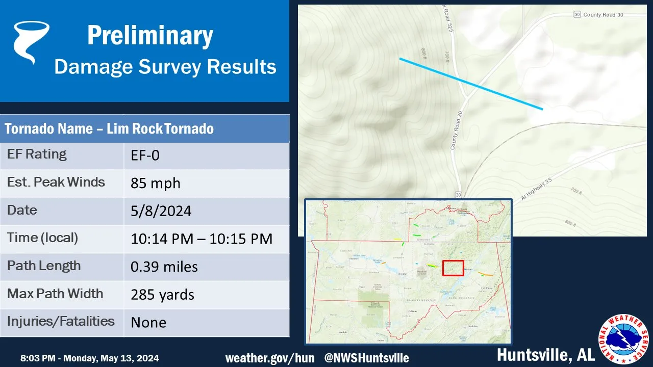
Rating:                 EF0
Estimated Peak Wind:    85 mph
Path Length /statute/:  0.39 miles
Path Width /maximum/:   285 yards
Fatalities:             0
Injuries:               0

Start Date:             05/08/2024
Start Time:             10:14 PM CDT
Start Location:         5 NE Woodville / Jackson County / AL
Start Lat/Lon:          34.6761 / -86.2202

End Date:               05/08/2024
End Time:               10:15 PM CDT
End Location:           5 NE Woodville / Jackson County / AL
End Lat/Lon:            34.6743 / -86.2138

Survey Summary:
On the evening of May 8th, a supercell thunderstorm moved
northwest to southeast across Lim Rock in Jackson County. A brief
tornado touched down just before County Road 525, crossing County
Road 30, before dissipating just shy of the railroad tracks north
of Hwy 35. A narrow path of hard and softwood tree damage was
noted along this path, consistent with 85mph winds (EF0) damage.
Further south of this track, sporadic tree damage was noted along
County Road 30 north of Hwy 35. This damage was outside of the
tornado path and was related to rear flank downdraft (RFD) winds
after further analyzing radar data.

Additional updates to this track start/end point are likely this
week as satellite and drone footage become available. Stay tuned
for further updates on the latest information as it becomes available.
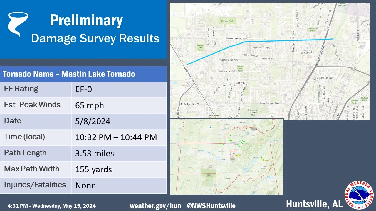
Rating:                 EF0
Estimated Peak Wind:    65 mph
Path Length /statute/:  3.53 miles
Path Width /maximum/:   155 yards
Fatalities:             0
Injuries:               0

Start Date:             05/08/2024
Start Time:             10:32 PM CDT
Start Location:         4 NNW Huntsville / Madison County / AL
Start Lat/Lon:          34.7624 / -86.6427

End Date:               05/08/2024
End Time:               10:44 PM CDT
End Location:           5 NNE Huntsville / Madison County / AL
End Lat/Lon:            34.7711 / -86.5824

Survey Summary:
A National Weather Service damage assessment team determined the
sporadic tree damage and minor home damage near Mastin Lake Rd.
was caused by a weak EF-0 tornado with max winds of 65 mph.

The short-lived and weak tornado began producing damage in between
Jordan Ln and Elton Rd. Minor roof damage and downed large limbs were
observed in this location. The tornado moved east, just south of
Mastin Lake Rd, and crossed N. Memorial Hwy. A concentrated path
of large limb damage indicators was recorded in along this path.
The tornado lifted east of Lakewood Rd.
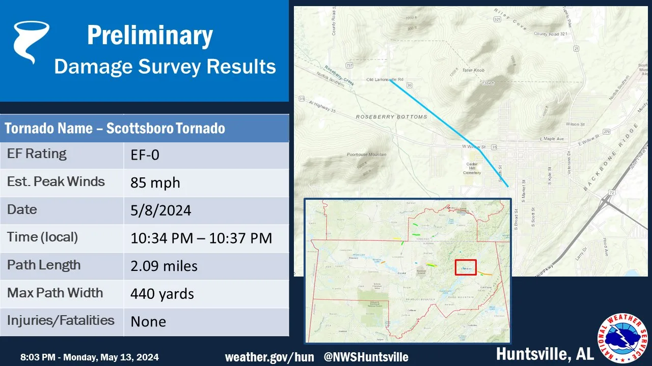
Rating:                 EF-0
Estimated Peak Wind:    85 mph
Path Length /statute/:  2.09 miles
Path Width /maximum/:   440 yards
Fatalities:             0
Injuries:               0

Start Date:             05/08/2024
Start Time:             10:34 PM CDT
Start Location:         3 NNW Scottsboro / Jackson County / AL
Start Lat/Lon:          34.6864 / -86.064

End Date:               05/08/2024
End Time:               10:37 PM CDT
End Location:           1 NNE Scottsboro / Jackson County / AL
End Lat/Lon:            34.6663 / -86.0369

Survey Summary:
An NWS Storm Survey determined a tornado touched down just west of
downtown Scottsboro. The initial touchdown point was indicated
by snapped tree branches on Old Larkinsville Rd. Scattered tree
damage was observed continuing generally southeast towards Highway
35. Limited infrastructure damage was found along Highway 35
including the peeling of metal roofing and siding. Between Highway
35 and Parks Ave several trees were found uprooted, snapped, and
with loss of limbs. Due to the limited infrastructure damage found
on Highway 35 and the uprooted trees, the maximum intensity of
this tornado was deemed an EF-0. Thank you to Jackson County EMA
and the Scottsboro Fire Department for their assistance during
this survey.
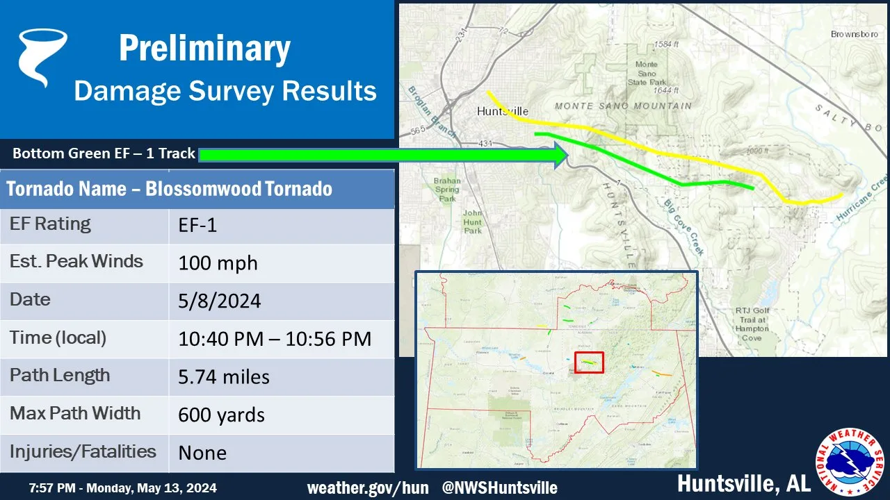
Rating:                 EF1
Estimated Peak Wind:    100 mph
Path Length /statute/:  5.74 miles
Path Width /maximum/:   600 yards
Fatalities:             0
Injuries:               0

Start Date:             05/08/2024
Start Time:             10:40 PM CDT
Start Location:         4 ENE Huntsville / Madison County / AL
Start Lat/Lon:          34.723 / -86.5598

End Date:               05/08/2024
End Time:               10:56 PM CDT
End Location:           5 W Gurley / Madison County / AL
End Lat/Lon:            34.7031 / -86.4635

Survey Summary:
A combination of NWS Storm Survey crews, drone imagery, and
supplemental Worldview 3 satellite imagery determined that an EF-
1 tornado tracked through southeast Huntsville just north of
Governors Drive. All damage noted was from snapped tree limbs and
uprooted trees along this track, primarily assessed from Worldview
3 satellite imagery. Within Dug Hill estates, there were multiple
trees uprooted or snapped causing significant roof damage to at
least two homes. The track continued across Monte Sano, past Dug
Hill Road, lifting just before Watson Grande Way.
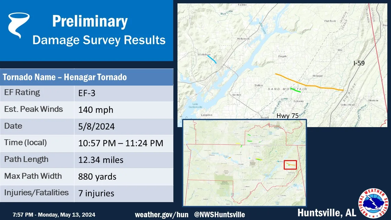
Rating:                 EF-3
Estimated Peak Wind:    140 mph
Path Length /statute/:  12.34 miles
Path Width /maximum/:   880 yards
Fatalities:             0
Injuries:               7

Start Date:             05/08/2024
Start Time:             10:57 PM CDT
Start Location:         3 S Pisgah / Jackson County / AL
Start Lat/Lon:          34.6407 / -85.8578

End Date:               05/08/2024
End Time:               11:24 PM CDT
End Location:           2 NNW Hammondville / DeKalb County / AL
End Lat/Lon:            34.5998 / -85.6497

Survey Summary:
The tornado touched down on Hwy 71 in Jackson County, snapping
hard and softwood trees to begin its path. The tornado continued
between County Road 425 and 322, producing minor damage to the
roof of a small farm building. The tornado then overturned a
camper and injured two people downstream along County Road 422.
Also at this location, a well-built home was partially destroyed.
A mobile home was moved off its foundation here as well, with a
third of the roof of a hay barn and a horse trailer destroyed.
Projectiles were found in the field across the street from this
home, with 2x4s impaled a foot to 18" in the ground at this
location. Further south and east along State Road 40, large 100+
year old oak trees that were 4-5 foot in diameter were blown down
onto a house, collapsing two exterior walls. Windows were sucked
out at this location as well prior to the trees falling when the
tornado passed just north of the house. Up the street, a well-
built home sustained major damage when the tornado ripped the
garage off of the house and sheared it to the north and east into
the rest of the dwelling. It was at this location that the highest
wind speed was rated for this tornado, 135 mph, which is the top
wind speed for an EF-2 tornado. Had anchor bolts been found in the
foundation anchoring of the walls (in lieu of the nails that were
found attaching the walls to the foundation), the tornado would
have been upgraded to an EF-3 tornado. What was left of the house
was in relatively good condition, all things considered, and it
was noted that the attic framing was anchored with strong ties,
and so the roof remained intact over a good portion of the house
otherwise. At this point, the tornado was likely at its widest
point, measuring 1.13 miles wide.

NWS representatives returned to the track the following day to
access several roadways that were completely blocked from
widespread fallen trees south of State Road 40. Surveyors found
damage indicators and degrees of damage consistent with EF3
(140 mph) tornado damage. The tornado was the strongest at this
point along the path. Along County Road 125, a well built shop
building was completely destroyed. The metal building structure
was well-anchored with H-beams anchored with large bolts and
plates at the bases to the foundation. The bolts were snapped and
severely bent, along with the plates. On one corner, a large 4-5
foot section of the foundation was ripped off the ground and
strewn about 10 feet away with the column anchoring still intact.
More shocking was the 20,000 pound 18-wheeler cab that was tossed
more than 150 yards into the field across CR 125. Other nearby
semi-trailers that were parked on the property were strewn in the
same direction as well, though most only were shifted 50-100 feet.

The tornado continued snapping and uprooting softwood trees over
the relatively rural landscape along Melton Drive and Elliot
Road. It was at this location where the road was impassable due to
numerous trees covering the roadway, and it was actively being
removed during our survey. Further east/southeast, the tornado
moved across the intersection of Culver/Keith/Lacey Roads,
snapping and uprooting more softwood trees. The tornado crossed
State Road 40, peeling back tin on several chicken houses between
SR40 and Valley Road, causing the structural integrity of one of
the houses to be compromised. Additional softwood trees were
uprooted and snapped near the intersection of County Road 714 and
120 along State Road 40 as well, with the loss of several roof
panels to a shed structure at a house located here.

Continuing on toward the latter part of the tornado track, a large
oak tree fell onto a house on CR 665 and 670. The tornado skipped
along uprooting and snapping more hard and softwood trees between
this location and the terminal point on Hwy 117 on the cusp of
Hammondville, mainly in rural Dekalb County. No additional damage
points were found beyond Hwy 117 and Interstate 59.

Thanks to both Jackson and Dekalb County EMA Offices, as well as
several Fire Departments in both counties for the support and
aid in completing these surveys.
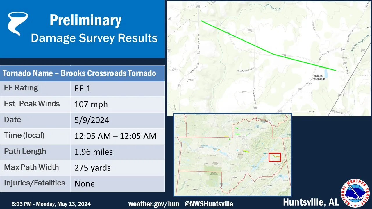
Rating:                 EF-1
Estimated Peak Wind:    107 mph
Path Length /statute/:  1.96 miles
Path Width /maximum/:   275 yards
Fatalities:             0
Injuries:               0

Start Date:             05/09/2024
Start Time:             12:02 AM CDT
Start Location:         3 NNW Sylvania / DeKalb County / AL
Start Lat/Lon:          34.605 / -85.812

End Date:               05/09/2024
End Time:               12:05 AM CDT
End Location:           3 NNE Sylvania / DeKalb County / AL
End Lat/Lon:            34.5953 / -85.7799

Survey Summary:
This tornado was associated with the second supercell that moved
across portions of Jackson and Dekalb Counties toward Brooks
Crossroads. Thankfully, this tornado went south of the EF-3 track
through Henagar, and was generally more weak and brief. This
tornado touched down on County Road 122, snapping and uprooting
hard and softwood trees just south of the Jackson/Dekalb County
border. The tornado continued moving to the east/southeast,
snapping and uprooting widespread trees along CR 122, consistent
with EF-1 damage and 107 mph winds in Brooks Crossroads. Though
there were numerous softwood trees that were damaged, notably,
there were several large 4-6 foot in diameter oak trees that were
likely 100 years or older that were snapped and uprooted. This led
to the slightly higher rating of the tree damage. Any structural
damage along this path was from trees that were felled by the
tornado, with minimal roof loss noted in this location.
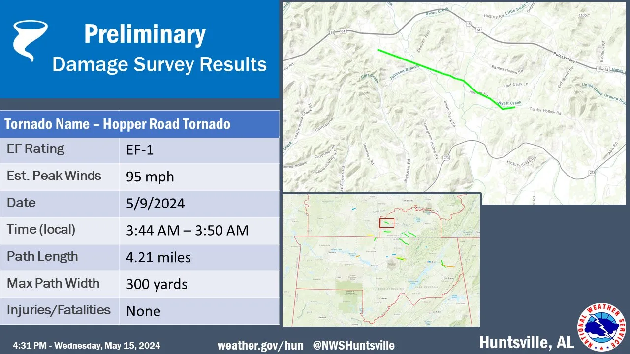
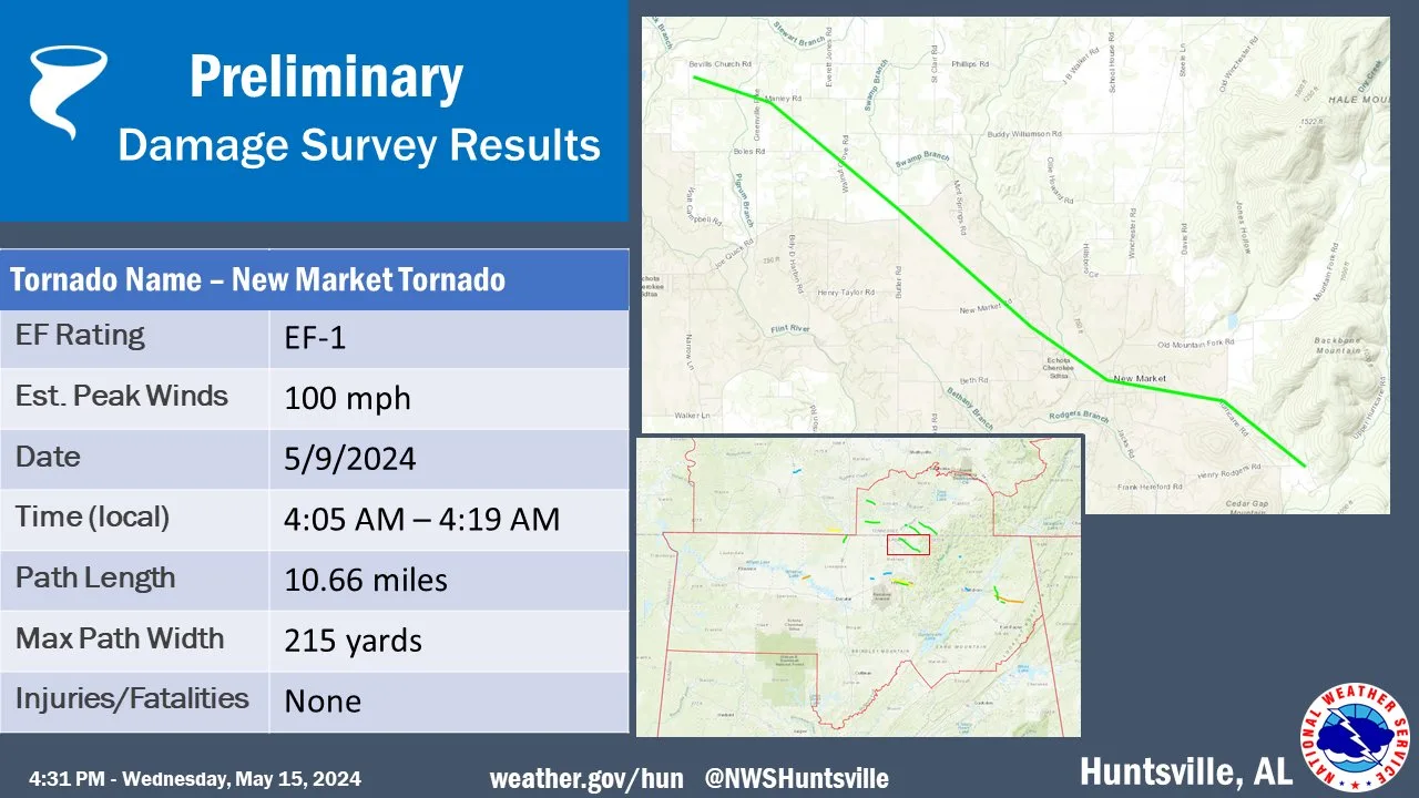
Rating:                 EF1
Estimated Peak Wind:    100 mph
Path Length /statute/:  10.66 miles
Path Width /maximum/:   215 yards
Fatalities:             0
Injuries:               0

Start Date:             05/09/2024
Start Time:             04:05 AM CDT
Start Location:         4 NNE Hazel Green / Madison County / AL
Start Lat/Lon:          34.9732 / -86.5342

End Date:               05/09/2024
End Time:               04:19 AM CDT
End Location:           3 ESE New Market / Madison County / AL
End Lat/Lon:            34.8922 / -86.3789

Survey Summary:
A tornado touched down along western portions of Bevills Church
Rd northeast of Hazel Green, uprooting a large hardwood tree and
breaking large branches. The tornado moved east-southeastward
producing damage along portions of Manley Rd, where a large
uprooted tree fell on a house causing roof damage. The tornado
proceeded southeastward mainly breaking large tree branches as it
moved into the area around the intersections of Butler Rd with
Mint Rd and Walnut Grove Rd. There, it produced loss of shingles
to a home and scattered areas of broken tree branches. The area
immediately to the southeast of here consists of broad farm
fields, however, tornado damage became evident again near the
intersections of Mint Springs Rd with New Market Rd. Trees were
uprooted and large branches snapped along New Market Rd as the
tornado continued on a generally southeastward path into New
Market where large tree branches were broken, including some
uprooted trees just east of town along Hurricane Rd. The tornado
continued southeastward, producing mainly broken large tree
branches sporadically along Hurricane Rd and finally near the
intersections of Dodson Ln and Upper Hurricane Rd, before
apparently lifting.
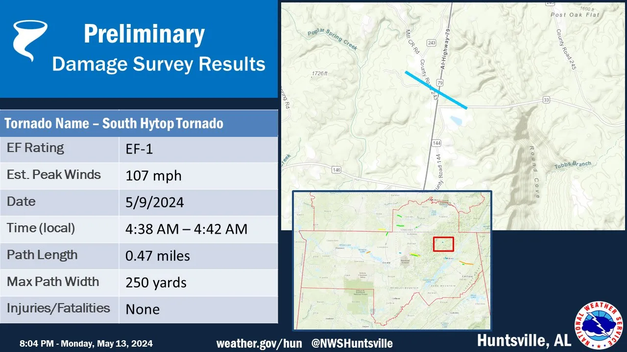
Rating:                 EF1
Estimated Peak Wind:    107 mph
Path Length /statute/:  0.47 miles
Path Width /maximum/:   250 yards
Fatalities:             0
Injuries:               0

Start Date:             05/09/2024
Start Time:             04:38 AM CDT
Start Location:         4 N Skyline / Jackson County / AL
Start Lat/Lon:          34.8664 / -86.1027

End Date:               05/09/2024
End Time:               04:42 AM CDT
End Location:           4 NNE Skyline / Jackson County / AL
End Lat/Lon:            34.8636 / -86.0951

Survey Summary:
A tornado touched down along portions of County Rd 243 just north
of the intersection with AL Highway 79. The tornado uprooted and
snapped trees at this location, one of which fell on a home
causing damage to the roof structure.  On the east side of
Highway 79 further spotty damage occurred, where the tornado
uprooted and snapped trees before lifting approximately one third
of a mile east of Hwy 79. This tornado track may change pending
additional surveys and the availability of high-resolution
satellite imagery.
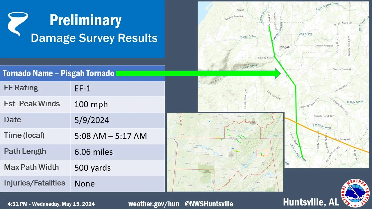
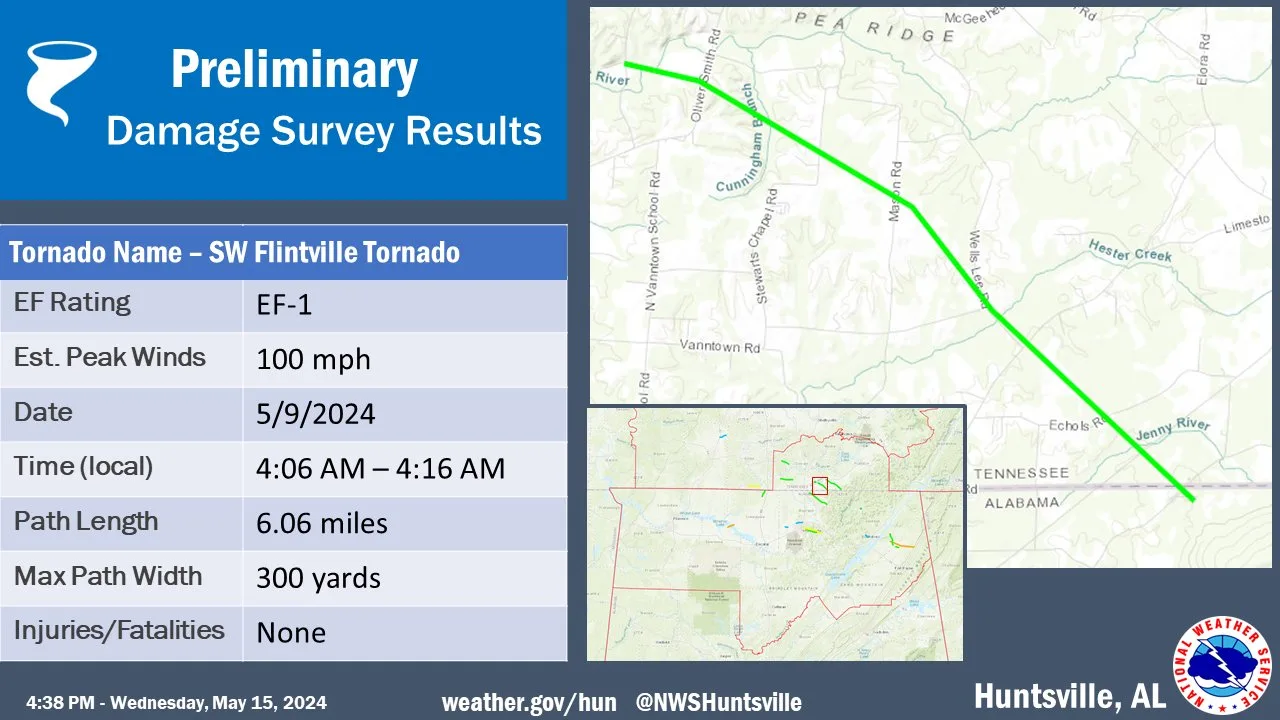
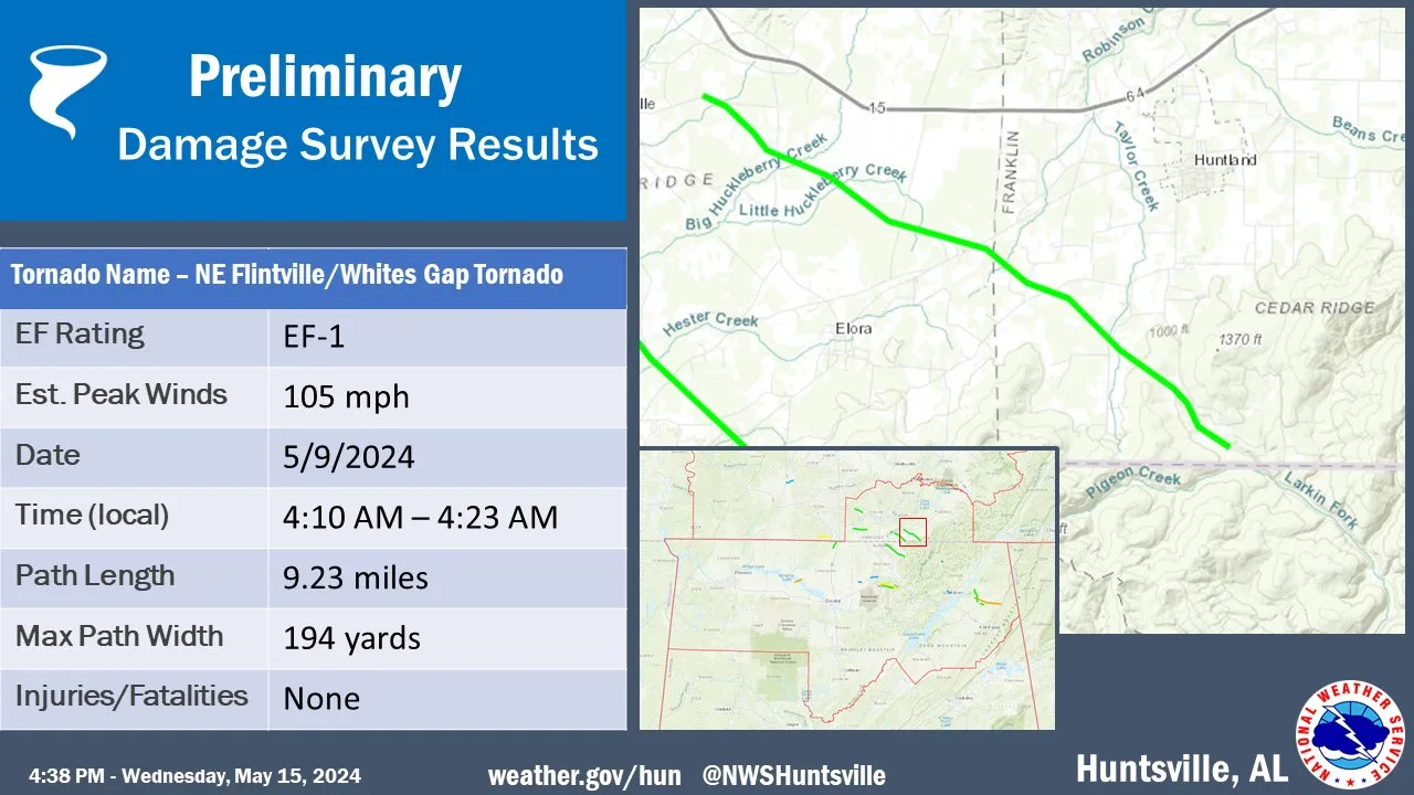
Rating:                 EF1
Estimated Peak Wind:    100 mph
Path Length /statute/:  6.06 miles
Path Width /maximum/:   500 yards
Fatalities:             0
Injuries:               0

Start Date:             05/09/2024
Start Time:             05:08 AM CDT
Start Location:         1 NW Pisgah / Jackson County / AL
Start Lat/Lon:          34.6949 / -85.8559

End Date:               05/09/2024
End Time:               05:17 AM CDT
End Location:           4 NNW Sylvania / Jackson County / AL
End Lat/Lon:            34.612 / -85.8302

Survey Summary:
An NWS Storm Survey determined that a tornado touched down on
County Road 432 north of County Road 88 where several large limbs
were snapped off of hardwood trees. The tornado then tracked
south-southeast just west of Pisgah causing sparse tree limb
damage before crossing County Road 372 and uprooting and snapping
several trees near a residence. At this point, the tornado
tracked southeast along County Road 58, uprooting several trees
along the way, before it crossed Highway 71 and tracked
southward. The track becomes difficult to identify south of
County Road 425, as it intersects with the Henegar EF-3 tornado
which occurred earlier that night. The track is identifiable once
more along Highway 40 where it continued southward before lifting
along County Road 392 with only sparse tree damage noted. Thank
you to Jackson County EMA for their assistance during this
survey.
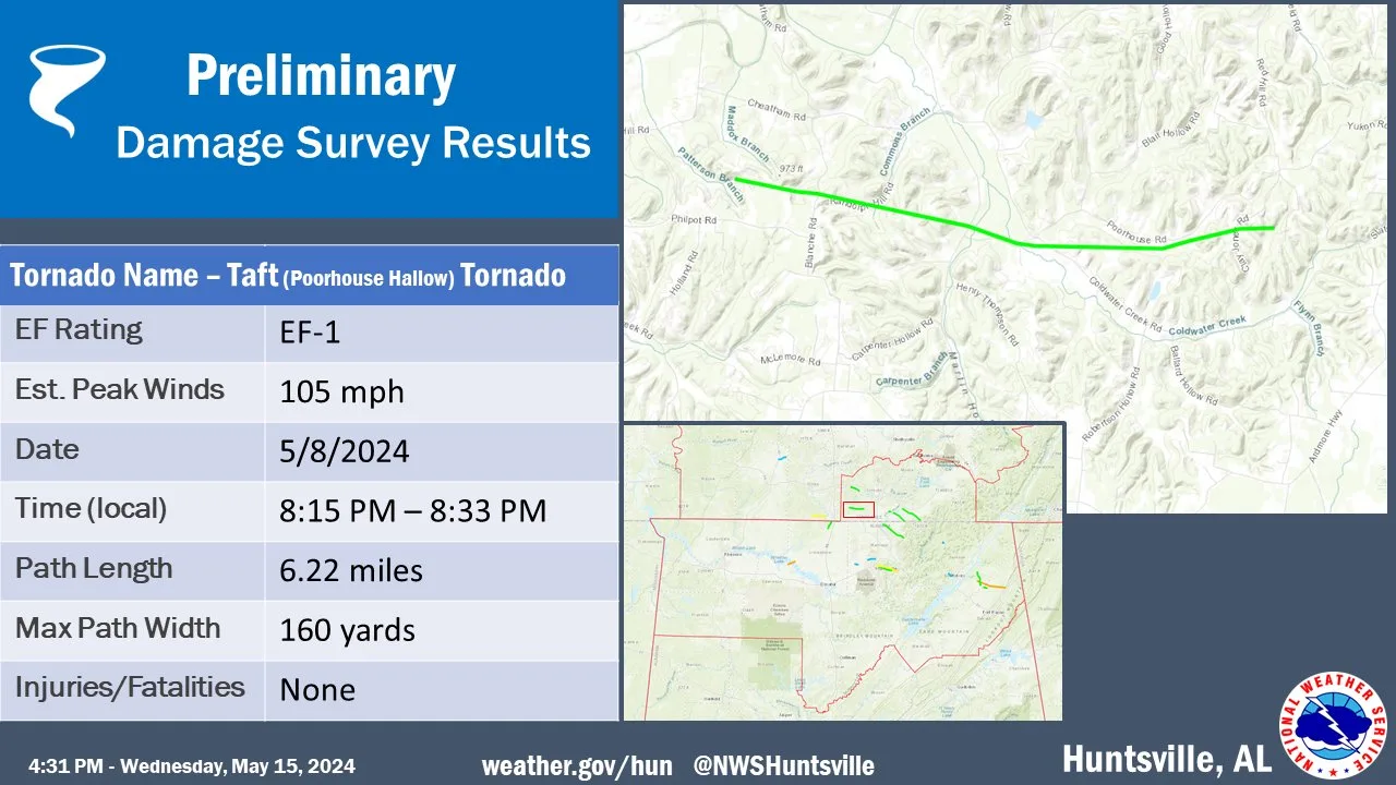
Rating:                 EF-1
Estimated Peak Wind:    105 mph
Path Length /statute/:  6.22 miles
Path Width /maximum/:   160 yards
Fatalities:             0
Injuries:               0

Start Date:             05/08/2024
Start Time:             08:15 PM CDT
Start Location:         6 NE Ardmore / Lincoln County / TN
Start Lat/Lon:          35.0728 / -86.7742

End Date:               05/08/2024
End Time:               08:33 PM CDT
End Location:           8 SW Fayetteville / Lincoln County / TN
End Lat/Lon:            35.0648 / -86.6665

Survey Summary:
A National Weather Service Huntsville, AL and Lincoln Co. EMA
damage assessment team determined the damage in southwest Lincoln
Co. was consistent with an EF-1 tornado with max winds of 105 mph.

Damage indicators across the tornado path were mostly a
combination of hardwood trees and sporadic, minor structure
damage. The tornado likely touched down near the Blanche Rd area
between Philpot Rd and Cheatham Rd. Hardwood numerous trees were
observed to be uprooted or trunks snapped with one tree on a
house. The tornado continued across Randolph Hill Rd then caused
more hardwood tree damage across Sanders Rd. The tornado then
followed Dry Creek, south of Poorhouse Rd, where numerous hardwood
trees were snapped through Clay Jones Rd. More significant
damage, including minor roof damage to a single-family house and
more dense areas of tree snaps, occurred east of Clay Jones Rd.
This is the location where the max winds were recorded by the
survey team. The tornado likely lifted east of this residence in a
valley west of Drennon Rd.
